Weekly weather planner: Pleasant start to the week in Louisville before summer heat returns
All outdoor activities are a go this week, but hydration will become important toward the end of the week. The weather forecast predicts a pleasant start to the week in Louisville before summer heat returns, with temperatures expected to reach mid-80s on Wednesday and near 90 on Thursday. The weather will remain dry throughout the week, but hydration will become crucial as a dry pattern takes over. Monday will be a bit cooler than average, but temperatures will warm up quickly as the dry pattern continues. The rest of the week will be mostly dry, with highs in the mid-70s and high temperatures in the upper 70s. Despite a potential heat wave on the weekend, temperatures are expected to increase by the weekend.
Opublikowany : 12 miesięcy temu za pomocą https://www.facebook.com/MeteorologistDanielJohnson, Daniel Johnson w Weather
METEOROLOGIST MATT MILOSEVICH. ALL RIGHT. WE’RE LOOKING REALLY NICE HERE THIS MONDAY MORNING. SUN FILLED SKIES COMING UP OVER THAT EASTERN HORIZON. WE’RE GOING TO START OUR DAY WITH LOTS OF SUN. WE’LL FILL IN SOME CLOUDS INTO THE AFTERNOON, BUT TEMPERATURES ARE VERY PLEASANT. WE’RE 63 AT ALI INTERNATIONAL, BUT MOST OF THE METRO SUBURBS AND OUTSIDE OF LOUISVILLE STARTING TO DIP INTO THE 50S IN MANY LOCATIONS MIDDLE 50S, INCLUDING 55 IN MADISON, 56 IN E-TOWN TO THE UPPER 50S IN BARDSTOWN AT 5857 SELLERSBURG. SO. VERY, VERY NICE START TO THE MORNING. WE’RE GOING TO BE PLEASANT THROUGH MOST OF THE DAY. LOTS OF SUNSHINE GETS US UP TO 75 MIDDAY. WE’RE GOING TO START TO NOTICE SOME NORTHERLY BREEZES KICK IN THOUGH. DURING THE AFTERNOON AS CLOUDS COME IN AND SKIES TURN A LITTLE MORE. PARTLY CLOUDY AND THAT SLOWS OUR WARMING TREND, SO SKIES WILL BE QUICK TO WARM THROUGH ABOUT MIDDAY AND THEN JUST INCH UP INTO THE UPPER 70S THROUGH THE AFTERNOON. I THINK WE’RE GOING TO PEAK RIGHT AROUND 4:00 AT 78, AND THEN ONCE THAT SUN SETS, WE’LL COME DOWN PRETTY QUICKLY INTO THE 60S. NOW, LOOKING AHEAD AT OUR RAIN OPPORTUNITIES, LOOK HOW DRY WE ARE MONDAY THROUGH THURSDAY, EVEN FRIDAY. ONE RAIN CHANCE. BUT THAT’S GOING TO BE PRETTY ISOLATED IN OUR SKIES. WE’RE GOING TO GO JUMP AHEAD IN LATE WEEK TIME FRAME. I WANT YOU TO NOTICE TO OUR NORTH AND WEST DURING THE DAY ON THURSDAY, THERE’LL BE A BLOW UP OF SOME SHOWERS AND STORMS. THIS IS A FRONTAL SYSTEM THAT’S GOING TO BE WEAKENING AS IT MOVES IN OUR DIRECTION. FRIDAY MORNING. THEY’RE GOING TO GET SOME GOOD SOAKERS BACK THROUGH CENTRAL PORTIONS OF ILLINOIS, BACK OVER INTO MISSOURI. BUT LOOK, AS IT HEADS OUR WAY, MOST OF THAT FADES AWAY. SO JUST A SPOTTY SHOWER POSSIBILITY ON FRIDAY. AND THAT’S GOING TO BE ABOUT IT IN THE SEVEN DAY FORECAST. I THINK MANY WILL BE STAYING DRY. WE SHOULD BE IN THE MID 80S FOR HIGHS AND MID 60S FOR LOWS. WE’RE BELOW THAT THE NEXT COUPLE OF DAYS. HIGHS IN THE UPPER 70S TODAY AND TOMORROW. LOWS WELL INTO THE 50S. THAT’S IN TOWN TONIGHT. THERE’LL BE SOME 40S OUTSIDE OF THE METRO TOMORROW MORNING. THEN WE START TO GET BACK CLOSER TO NORMAL AT 86 ON WEDNESDAY, A HOT DAY THURSDAY AT 90. WE’LL WATCH THAT ISOLATED SHOWER CHANCE ON FRIDAY, BUT BY THE WEEKEND WE REALLY CRANK UP THE HEAT.
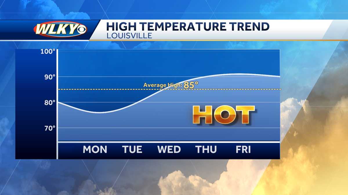
Weekly weather planner: Pleasant start to the week in Louisville before summer heat returns All outdoor activities are a go this week, but hydration will become important toward the end of the week. Put away the umbrellas and grab the sunglasses as a dry pattern takes over this week. It will start out on the seasonably cool side before a potential heat wave hits the area late in the week.Monday will be a nice day but a bit cooler than average. We'll start with some sunshine in the morning, then some clouds roll in for the afternoon hours. Highs will be in the 70s.As the cooler-than-normal air settles into the area, chilly overnight lows are expected Monday night. A few isolated rural spots could drop into the 40s.Tuesday looks like a beautiful day with sunny skies and high temperatures in the upper 70s.The rest of the week will warm up quickly as the dry pattern continues. We'll reach the mid-80s on Wednesday, then near or above 90 degrees on Thursday and Friday. As of now, it looks like the heat will continue into Father's Day weekend. Here's the seven-day forecast. Put away the umbrellas and grab the sunglasses as a dry pattern takes over this week. It will start out on the seasonably cool side before a potential heat wave hits the area late in the week. Monday will be a nice day but a bit cooler than average. We'll start with some sunshine in the morning, then some clouds roll in for the afternoon hours. Highs will be in the 70s. As the cooler-than-normal air settles into the area, chilly overnight lows are expected Monday night. A few isolated rural spots could drop into the 40s. Tuesday looks like a beautiful day with sunny skies and high temperatures in the upper 70s. The rest of the week will warm up quickly as the dry pattern continues. We'll reach the mid-80s on Wednesday, then near or above 90 degrees on Thursday and Friday. As of now, it looks like the heat will continue into Father's Day weekend. Here's the seven-day forecast.