Weekend weather planner: Starting sunny, but shower chances possible
Starting out dry and sunny for Friday, but a few shower chances are possible as we move through the weekend. Meteorologist, MOOSE Rose, has provided a detailed weekend weather planner for the U.S. starting with clear skies and mild temperatures, but potential shower chances are possible. High pressure will bring us lots of sunshine and low humidity throughout the weekend, with temperatures expected to remain below normal. The weather will be mostly sunny and dry for Friday and Saturday, but with a few showers possible as we move through the weekend. Temperatures are expected to stay below normal and temperatures will remain below the normal. Showers are expected throughout the week, but there will be a potential for heavy rainfall throughout the summer.
Опубликовано : 12 месяцев назад от https://www.facebook.com/WLKYMoRose, Mo Rose в Weather
METEOROLOGIST MO ROSE. GOOD FRIDAY MORNING TO YOU. WE’VE GOT CLEAR SKIES AND VERY COMFORTABLE TEMPERATURES. VERY SIMILAR TO WHAT WE HAD YESTERDAY. AS FAR AS THE NUMBERS GO, 67 AROUND THIS TIME YESTERDAY. BUT THE DEW POINT IS A WHOLE LOT DIFFERENT. IT’S GOING TO FEEL VERY REFRESHING WHEN YOU WALK OUT THE DOOR THIS MORNING. WE’VE GOT WINDS OUT OF THE WEST AT EIGHT MILES PER HOUR, AND WE’RE SEEING 50 QUITE A BIT OF THEM OUTSIDE OF THE CITY, 59 IN MADISON, 57 IN BARDSTOWN. WE’RE AT 56 IN E-TOWN AND UPPER 50S IN BRANDENBURG AND GRAYSON COUNTY. AND IN THE 12 HOUR FORECAST, I THINK WE STILL HAVE A COUPLE MORE DEGREES TO DROP BEFORE THE SUN COMES UP, AND THEN WE WARM BACK INTO THE AFTERNOON. BUT 63 BY SEVEN WILL BE IN THE MID 60S, BY NINE IN THE LUNCHTIME AROUND THE MID 70S AND THEN GETTING CLOSE TO 80 LATER ON THIS AFTERNOON. AND LOOK AT ALL OF THE SUNSHINE. LOVE IT. YOU WILL NOT NEED THAT UMBRELLA TODAY. HIGH PRESSURE IS IN CONTROL. IT’S GOING TO BRING US VERY TRANQUIL CONDITIONS THROUGH THE AFTERNOON. THEN WE GET TO THE WEEKEND. COUPLE OF DISTURBANCES OUT TO THE WEST ARE GOING TO START MAKING THEIR WAY TOWARDS US. AND SO BY LATE TONIGHT, EARLY SATURDAY MORNING WE’LL START SEEING INCREASING CLOUD COVER. AND WE’LL ALSO BE WATCHING FOR SOME SHOWERS. SO IN OUR FUTURE RADAR, YOU SEE NOTHING HAPPENING ON THE SCREEN THERE. IT’S LATER ON TONIGHT WE’LL START SEEING CLOUDS MOVE IN. NO PROBLEMS HERE. EARLY IN THE MORNING WE’LL START TO WATCH FOR MAYBE A COUPLE OF SHOWERS TO MOVE THROUGH BY THE AFTERNOON. WE’RE ALREADY DRYING OUT AGAIN, AND THEN WE’LL HAVE JUST A LITTLE BIT OF SUNSHINE THROUGH THE AFTERNOON AHEAD OF THE COLD FRONT. DEPENDING ON HOW WARM WE GET ON SATURDAY. AND I THINK THE CLOUD COVER IS GOING TO WORK IN OUR FAVOR, WE WILL JUST WATCH FOR SOME RUMBLES OF THUNDER, SOME HEAVY RAIN, SOME DOWNPOURS IS GOING TO BE A REAL JUICY SYSTEM. MOVING THROUGH SO WE COULD HAVE SOME HEAVY RAIN AT TIMES, BUT THIS IS OVERNIGHT ON SATURDAY INTO SUNDAY, SO DON’T CANCEL YOUR OUTDOOR PLANS. I THINK THE RAIN IS GOING TO WORK IN OUR FAVOR. WE’LL HAVE IT EARLY ON SATURDAY. THEN ONCE. AGAIN SATURDAY NIGHT INTO SUNDAY MID 70S FOR THE HIGH. SO A LITTLE COOLER THAN NORMAL FOR SATURDAY. WE’RE BACK TO 80 ON SUNDAY. ANY RAIN SHOULD BE OUT OF HERE BY THE LATE MORNING AND THEN WE’RE DRIER IN THE AFTERNOON AND THEN WE STAY DRY. LOOK AT THE REST OF THAT SEVEN DAY FORECAST. UPPER 70S ON MONDAY, 80 ON TUESDAY AND THEN WARMING TO MORE SUMMER-LIKE CONDITIONS FOR
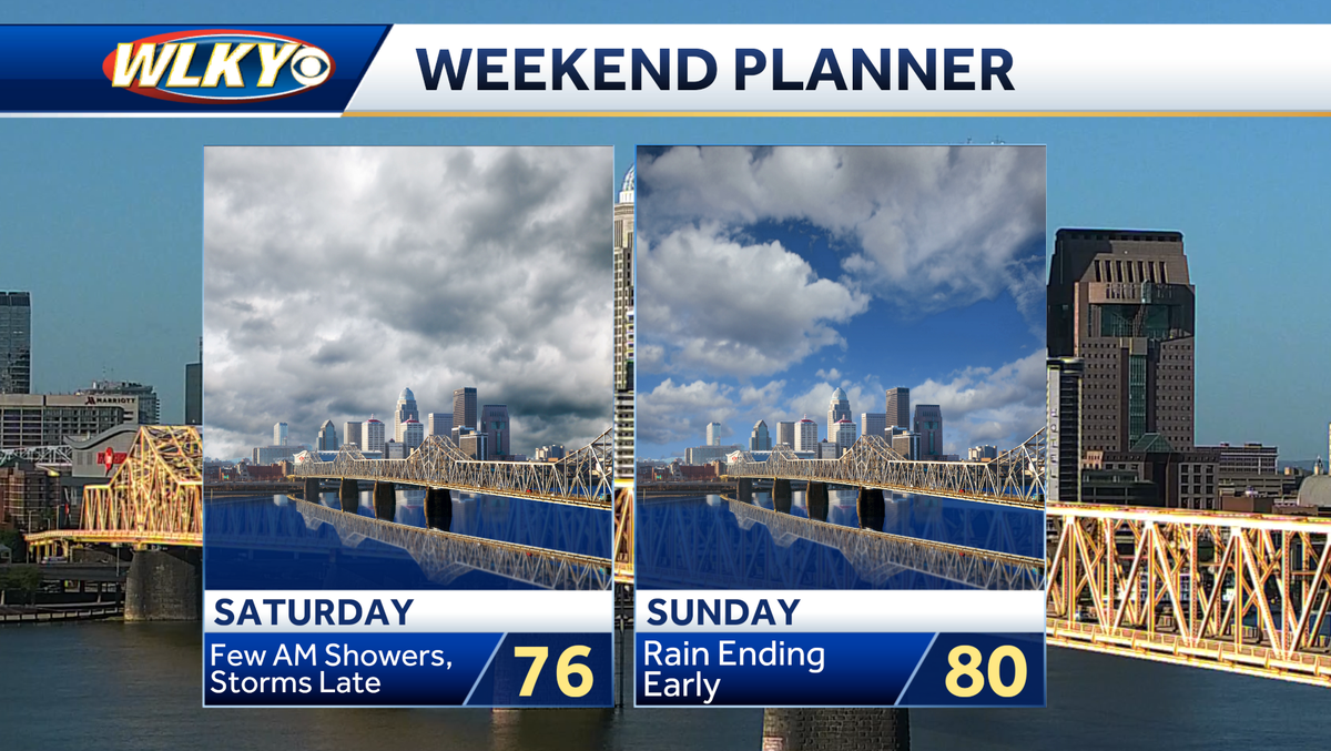
Starting out dry and sunny for Friday, but a few shower chances are possible as we move through the weekend Starting out dry and sunny for Friday, but a few shower chances are possible as we move through the weekend.High pressure overhead will bring us lots of sunshine and low humidity to start the weekend. Temperatures will land a touch below normal with a high near 80. Evening skies will remain clear for the most part. However, clouds move in after midnight with lows in the low 60s. We'll watch for a few showers during the morning hours on Saturday, with a good amount of dry time during the afternoon. Temperatures will remain below normal thanks to the mostly cloudy skies. Rain and a few storms sweep through along a cold front overnight on Saturday, with a few showers lingering into Sunday morning. Then drier late day with increasing sunshine and a high near 80. Starting out dry and sunny for Friday, but a few shower chances are possible as we move through the weekend. High pressure overhead will bring us lots of sunshine and low humidity to start the weekend. Temperatures will land a touch below normal with a high near 80. Evening skies will remain clear for the most part. However, clouds move in after midnight with lows in the low 60s. We'll watch for a few showers during the morning hours on Saturday, with a good amount of dry time during the afternoon. Temperatures will remain below normal thanks to the mostly cloudy skies. Rain and a few storms sweep through along a cold front overnight on Saturday, with a few showers lingering into Sunday morning. Then drier late day with increasing sunshine and a high near 80.