How tropical storms, hurricanes have impacted the Ohio Valley in years past
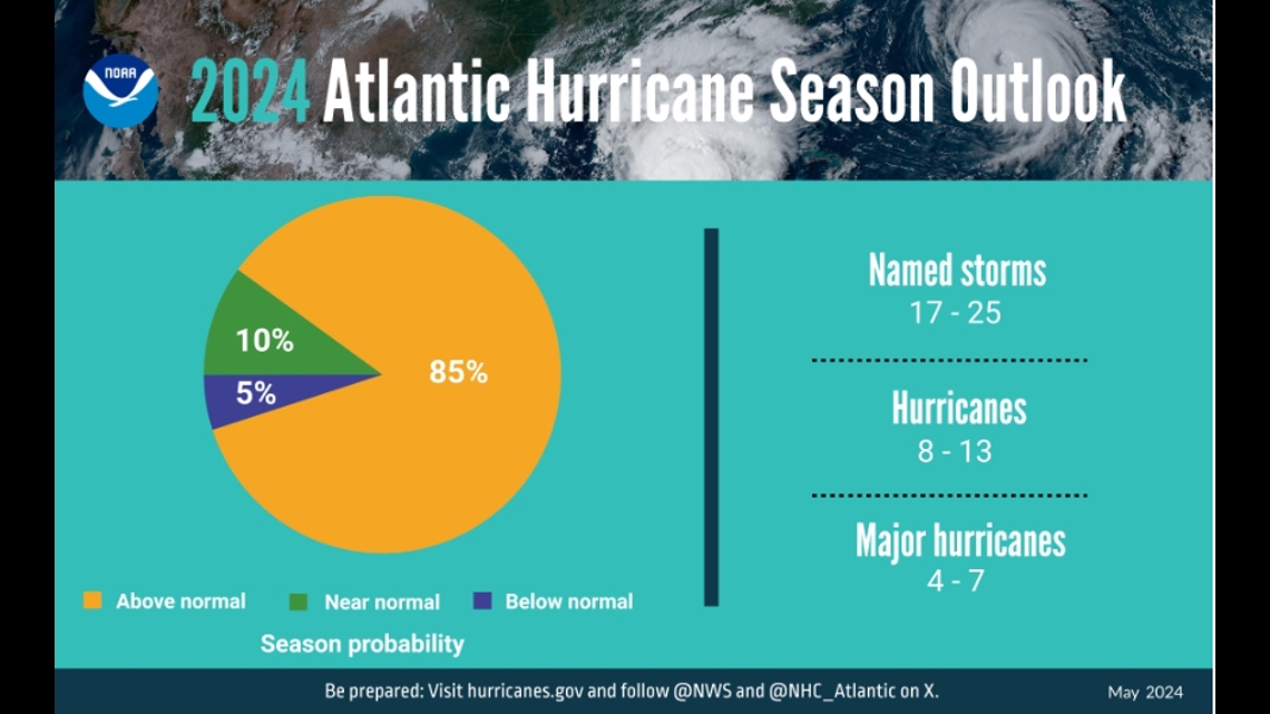
Though no storms are currently brewing in the tropics, the 2024 Atlantic hurricane season is here. The 2024 Atlantic hurricane season is set to begin, with an 80% chance of an above-normal season with 17-25 named storms and 4-7 major hurricanes predicted to become major hurricanes. The names of these storms are chosen in advance, with the first named storm set to be Alberto, followed by Beryl, and Chris. This list includes several notable storms that have impacted the Ohio Valley, including Hurricane Camille in 1969, Hurricane Ike in 2008, and Hurricane Olga in the Gulf of Mexico.
Yayınlanan : 12 ay önce ile Christina Sanjuan içinde Weather
Though no storms are currently brewing in the tropics, the 2024 Atlantic hurricane season is here.
The National Oceanic and Atmospheric Administration’s (NOAA) Climate Prediction Center has forecasted an 80% chance of this year being an above-normal season with 17-25 named storms. Out of those storms, 4-7 are predicted to become major hurricanes (category 3+).
As always, the names for the storm season are chosen in advance and will go in alphabetical order. The first named storm for the 2024 Atlantic hurricane season will be Alberto, second will be Beryl, third Chris and so on.
While it is not common for hurricanes to bring significant impacts as far inland as Kentucky and Indiana, it has happened several times in years past.
Below, we will go through some of the most notable storms that have brought significant wind, rain, and/or thunderstorms to the Ohio Valley.
Hurricane Camille brought complete devastation to the Mississippi coast in August of 1969, making landfall as a category 5 hurricane. It is the second most intense hurricane on record to hit the United States. Camille had weakened to a tropical depression as it moved through the Tennessee Valley and eventually through Kentucky. It brought heavy rain that resulted in flooding and landslides to the state. Camille continued east through Virginia and eventually back into the Atlantic, where it went on to regain tropical storm strength.
Hurricane Ike changed the landscape of the Galveston and Houston areas in 2008 by making landfall as a high end category 2 hurricane. Ike eventually weakened as it traveled northeast, but its remnants still brought hurricane force wind gusts as far inland as southern Indiana. The extreme wind knocked down trees and over 1,000 power lines in the Louisville area, resulting in over 300,000 power outages. Sadly, there were four fatalities in this area due to falling trees and branches.
Gordon's remnants passed slowly across the Ohio Valley after making landfall in far eastern Alabama as a strong tropical storm. Heavy rainfall resulted in flash flooding, and severe thunderstorms produced two EF-0 tornadoes in Kentucky and Indiana. One tornado touched down in Tell City, IN and another formed in Lewisport, KY.
The name "Gordon" happens to be on this year's list of storm names. Storm names are recycled every six years, unless the storm is particularly damaging/devastating (in that case the name will be retired).
Though Olga only reached tropical storm status in the Gulf of Mexico for a brief period of time, the storm went on to move inland via eastern Louisiana and traveled northward through the United States. Olga's remnants packed damaging wind gusts and drought busting rainfall to portions of Kentucky and southern Indiana. Peak wind gusts were in the 60-80 mph range from Hopkinsville, KY to Owensboro, KY and Ferdinand, IN. These communities experienced narrow swaths of wind damage resulting in power outages.
Make it easy to keep up-to-date with more stories like this. Download the WHAS11 News app now. For Apple or Android users.