Weekend weather planner: Easter Edition
We're warming up for Easter weekend but also watching for multiple rain chances. The National Weather Service has issued a weather update for the Easter weekend, with temperatures expected to reach the mid-70s, with some light showers and partly sunny conditions. The rest of the weekend is expected to be warm but unsettled, with a few spotty showers by Saturday morning and mild lows in the 50s. Temperatures are expected to drop to the low 70s with lots of sunshine throughout the weekend, but temperatures will remain warm and dry. A big storm system is predicted to shift east to the west, potentially leading to SHOWERS and THUNDERSTORMS early next week. The weather service is also monitoring a potential impact on impact on Monday until Tuesday.
Published : 4 weeks ago by https://www.facebook.com/WLKYMoRose, Mo Rose in Weather
SURE. ALL RIGHT. LET’S TALK A LITTLE BIT ABOUT YOUR FRIDAY WEATHER. WE’VE GOT 50 DEGREES RIGHT NOW TO KICK OFF THE 12 HOUR FORECAST. WE’RE JUST GOING TO SEE A FEW PASSING CLOUDS IN OUR SKIES TODAY AND LOOK AT THE JUMP IN. TEMPERATURES WILL DIP TO 47 BY 8:00. BUT THEN WE’LL BE PUSHING 60 DEGREES AT 1170 FOR THE AFTERNOON AFTER LOW 60S YESTERDAY. WE’RE GOING TO TOP OUT LATE DAY AROUND 73 DEGREES. GOING TO BE REALLY NICE OUT THERE. NOW WE’RE 50 IN TOWN, BUT MOST OF THE METRO SUBURBS AND OUTSIDE OF LOUISVILLE, LOWER TO MIDDLE 40S ARE THE RULE. A COUPLE OF 30S ON THE CHILLIER SIDE IN E-TOWN AND BARDSTOWN, COMING IN AT 38 DEGREES. BUT WE’LL SEE A GOOD DEAL OF SUNSHINE. THERE’S A FEW OF THOSE PASSING CLOUDS ON FORECAST RADAR, BUT THE RADAR STAYS DRY REGARDLESS OF CLOUD COVER THROUGH THROUGH THE MORNING AFTERNOON. YOUR EVENING PLANS LOOK GOOD AS WELL. BATS ARE KICKING OFF THE SEASON THIS EVENING. TEMPERATURES WILL BE FALLING INTO THE 60S. IT’S GOING TO BE REALLY PICTURE PERFECT WEATHER OUT AT SLUGGER FIELD LATER ON TONIGHT. WE ARE LOOKING AT A FEW SHOWERS CHANCES THAT TRY TO SNEAK IN FROM THE NORTH TOMORROW MORNING. I THINK THESE ARE GOING TO BE PRETTY SPOTTY AND MAINLY NORTH OF THE METRO, BUT THROUGH THE MID MORNING HOURS WE COULD SEE A FEW BLIPS ON THE RADAR THERE TO KICK OFF THE WEEKEND. BUT AS WE HEAD INTO THE AFTERNOON NOTICE THAT THE DRY SKIES TAKE OVER TEMPERATURES JUMP INTO THE MIDDLE 70S AND WE’RE GOING TO SEE A SIMILAR WEATHER PATTERN FOR SUNDAY. TWO COUPLE OF SHOWERS, EVEN A RUMBLE OF THUNDER CAN’T BE RULED OUT FOR THE MORNING. AND THEN WE’RE DRIER SUNDAY AFTERNOON. IT’S ALL PART OF A BIGGER STORM SYSTEM THAT’S STARTING TO TAKE SHAPE OUT TO THE WEST, AND IT WILL BRING OUR BETTER CHANCES FOR SHOWERS AND THUNDERSTORMS INTO EARLY NEXT WEEK. SO FOR TODAY, WE’RE 73. THERE’S THE WARMTH IN THE MIDDLE 70S, LOWS IN THE MILD 50S THROUGH THE WEEKEND, AND SOME MORNING SHOWER CHANCES BOTH TOMORROW AND SUNDAY. BUT A LOT OF DRY TIME THROUGH THE WEEKEND. IMPACT WEATHER COMES OUR WAY MONDAY INTO TUESDAY. A FEW OF THOSE STORMS COULD BE ON THE STRONG SIDE, WITH A FRONT THAT KNOCKS US INTO THE CHILLIER 50S, EVEN WITH
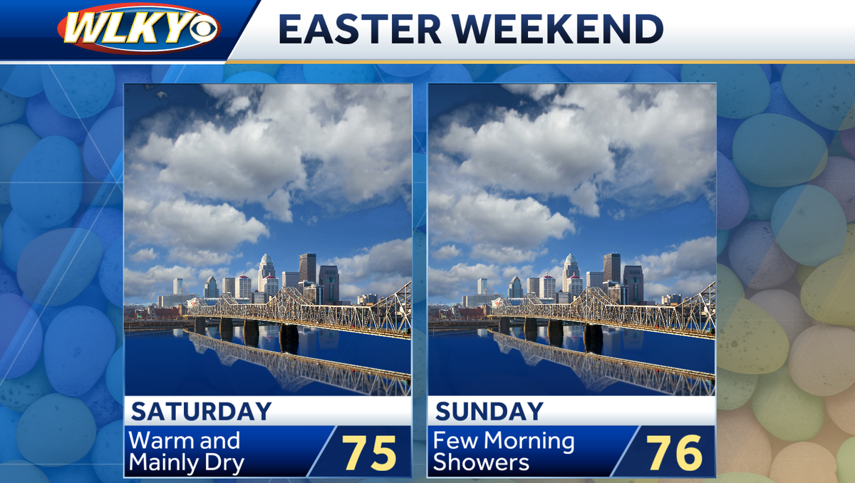
We're warming up for Easter weekend but also watching for multiple rain chances We're warming up for Easter weekend, but also watching for multiple rain chances. It'll be a dry and warm start to the weekend, with temperatures heading into the low 70s with lots of sunshine. We'll begin to see more clouds Friday night with a few spotty showers by Saturday morning with mild lows in the 50s. The rest of your Easter weekend is warm but unsettled. Saturday has temperatures in the mid-70s, with some light showers early and partly sunny skies later. Sunday has a better chance for isolated showers and maybe a rumble of thunder, especially early. Trending drier later in the day. We're warming up for Easter weekend, but also watching for multiple rain chances. It'll be a dry and warm start to the weekend, with temperatures heading into the low 70s with lots of sunshine.
We'll begin to see more clouds Friday night with a few spotty showers by Saturday morning with mild lows in the 50s. The rest of your Easter weekend is warm but unsettled. Saturday has temperatures in the mid-70s, with some light showers early and partly sunny skies later. Sunday has a better chance for isolated showers and maybe a rumble of thunder, especially early. Trending drier later in the day.